


A Modest Springtime Proposal Directed Towards Readership Geologists
Regarding Nevada Gold Exploration, and Working through that Pesky Ore Cover Problem
Introduction
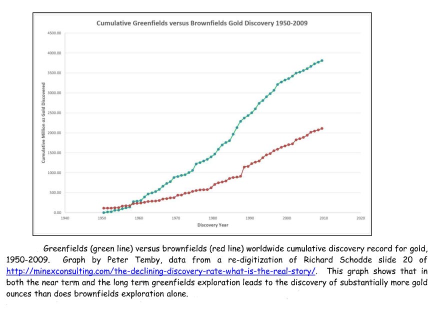
As shown below, greenfields exploration — not brownfields exploration —provides the most value to the mining industry.
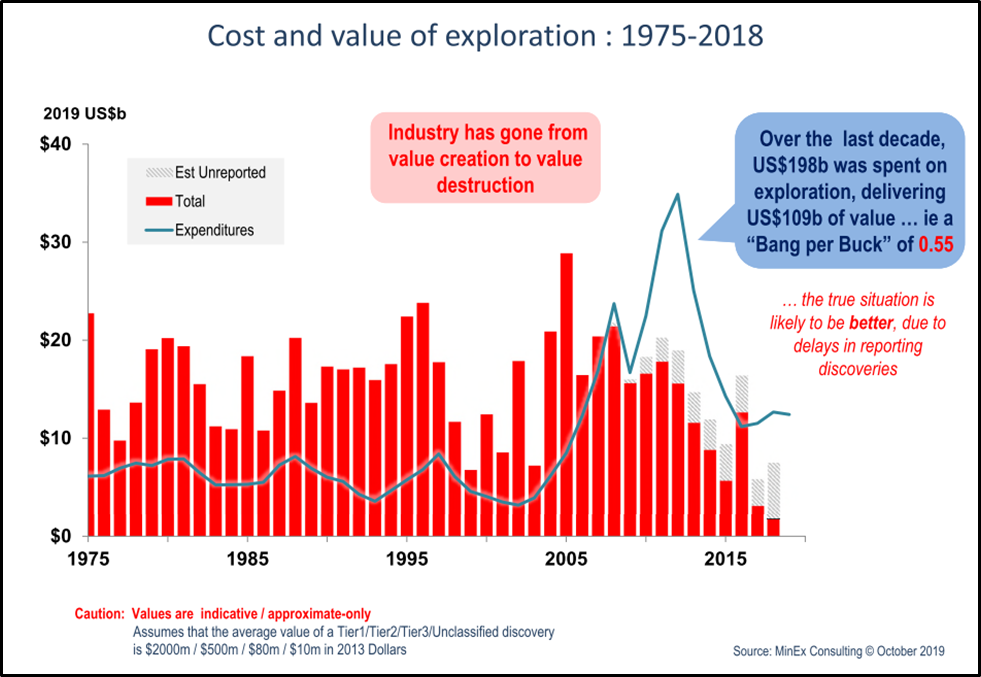
However, the next graph illustrates the economic result of the most basic and most serious technical problem now facing the mineral exploration industry and its dependent, the mining industry. Since about 2007, it costs, on average, considerably more to find an ore deposit than the value eventually obtained from the ore production from that deposit.
The ultimate source of this technical problem causing economic consequences can be detected in the next graph. According to the data, historical greenfields exploration techniques have quite limited ability to find wealth-creating ore deposits that are deeper than about 100-150 feet below the surface.
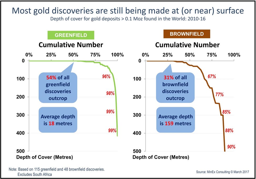
And, given the amount of time most of the world’s surface has been very actively prospected and explored by humans, most of the surface and near surface ore deposits have already been found by greenfields exploration work.
But, despite the relatively weak ability of greenfields mineral exploration geology to find anything besides shallow ore deposits, what does the following diagram show?
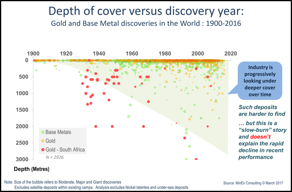
Clearly, year after year, most gold and base metal deposit discoveries across the world are found at or very near the surface, due to the historical technical limitations of greenfields exploration. Nevertheless, as time has gone on, this same graph indicates that, with the deeper drilling exploration that characterizes most of brownfields exploration, ore can still reliably be found at greater depths. The greenfields exploration technical problem, then, is not that ore deposits themselves have become rarer and rarer and are now permanently played out globally, but -- instead -- that the dominant, surface-focused methods of greenfields mineral exploration most commonly employed by greenfields geologists are themselves played out.
The challenge, then, is to generate new greenfields ore discoveries at at least marginally greater depths (i.e., at least > 150 feet) in order to generate enough new mineral wealth that the mineral exploration industry once again returns to consistent value creation .
Which Brings Me to This
Those who earlier read:

may recall my brief description and general explanation there of how DIR Exploration, Inc.'s "novel geochemical method" of combining modern day ICP-MS multi-element analyses of surface samples with geological theory-guided linear regression can be used in greenfields exploration to detect and estimate resource magnitude of buried ore deposits.
A detailed case history of the utility, and a thorough explanation, of this “novel geochemical method” for getting much more from surface exploration geochemical data is provided here: https://www.dropbox.com/s/t9jboxu5wdeiv4b/TurnerAIPGFormat102116.pdf?dl=0
First off, the following graph illustrates how one typical numerical component of this novel geochemical method of handling exploration geochemical data extends depth of geochemical detection of ore deposits under cover down to at least 1250 feet – well below the usual 100-150 foot depth limit of ore deposit discovery.1
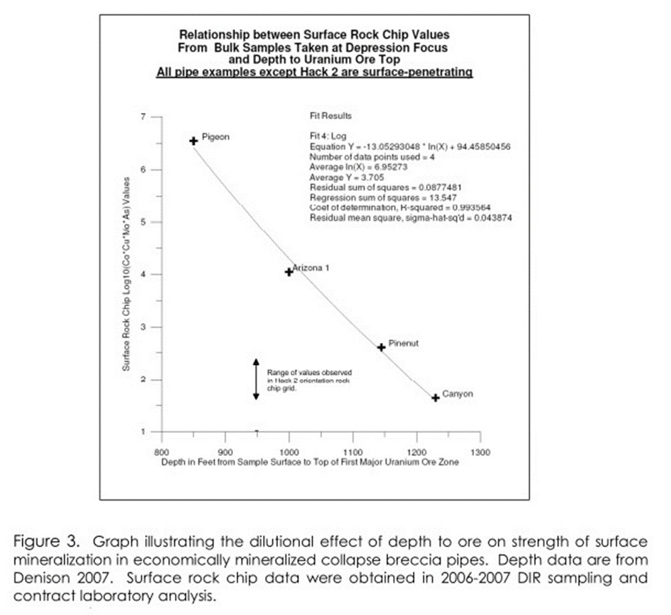
Illustration of the second important methodological utility of the novel geochemical method — being able to estimate magnitude of buried mineral resource from surface (pre-drilling) samples — is shown below for the northern Arizona uranium-mineralized collapse breccia pipes type-case. This illustration from the Arizona uranium mineralization province is followed by a similarly derived example concerning the Carlin-type gold deposits of Nevada. See these two graphs below.
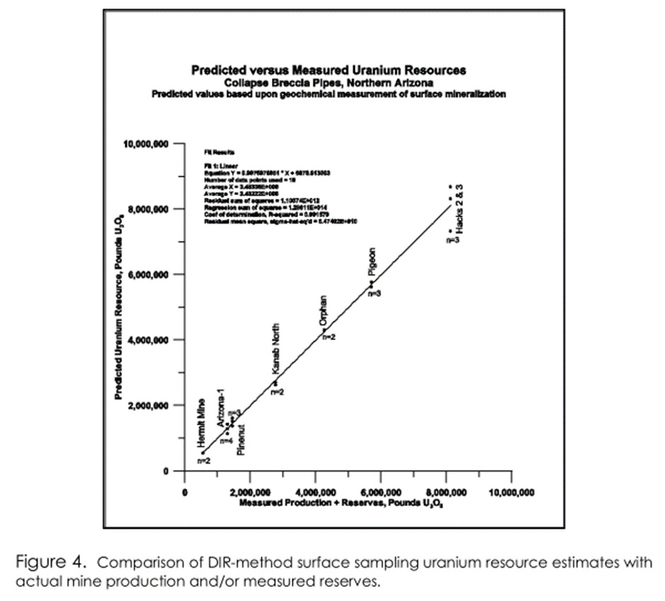
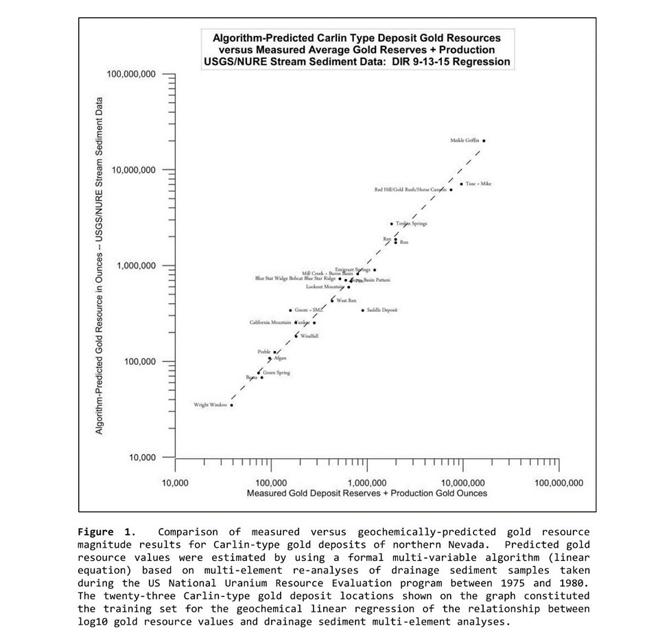
The surface samples used in the Arizona uranium examples above are bulk rock chip samples taken by DIR Exploration, while the surface samples in the Nevada Carlin-type gold deposit case-study illustraions are stream sediment samples taken as a part of the 1975-1980 federal National Uranium Resource Evaluation (NURE) program. Note that this ‘legacy’ stream sediment sampling work took place in Nevada well before the discovery and mining of most of the Carlin deposits identified on the Nevada graphs and maps provided in this post; i.e., before very much late 20th century gold mining-related disturbance and possible contamination of the surface rocks, soils, and drainage sediments took place in northern Nevada.
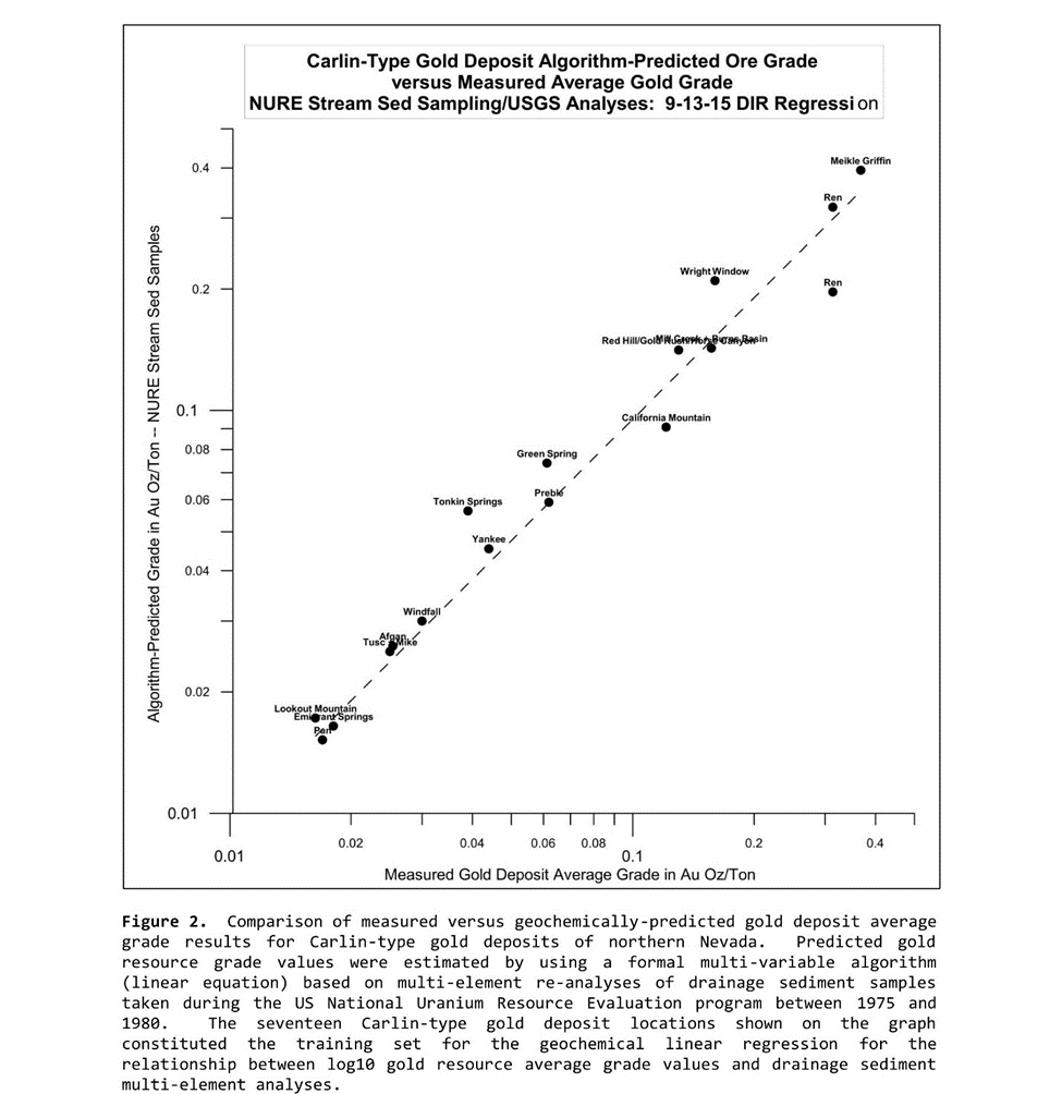
Very surprisingly, in the Carlin-type gold deposit case,2 it is evidently not only possible to detect the deep presence of buried gold ore and estimate its resource magnitude from surface sampling, but it appears also possible to obtain a rough estimate of average resource grade from the same surface sampling media and laboratory analyses.3 The following graph demonstrates this further apparent capability of the novel geochemical method being discussed.
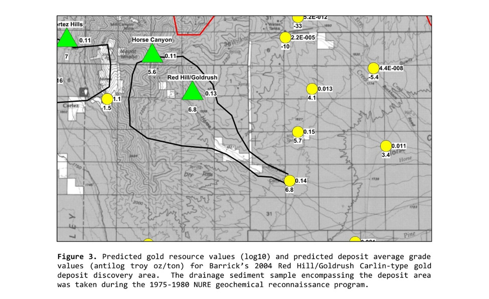
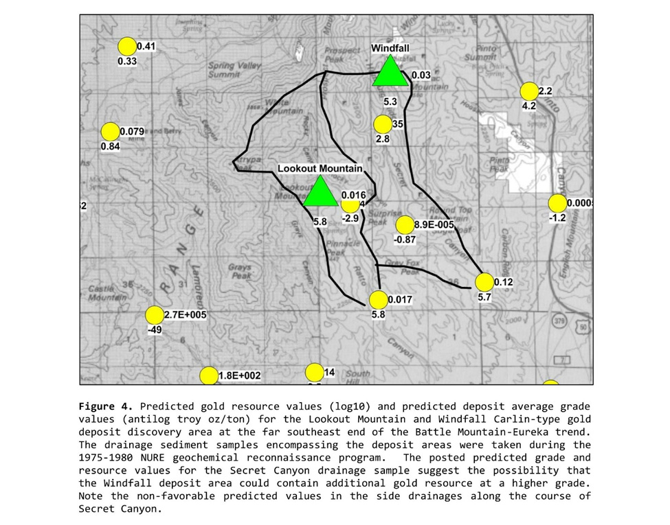
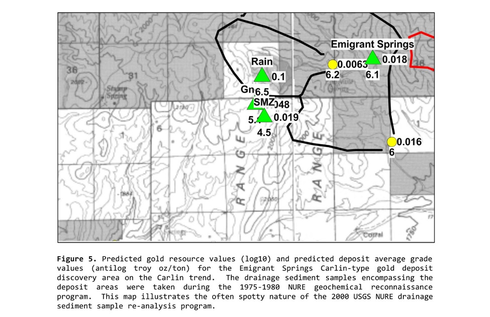
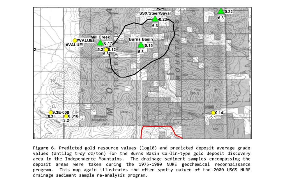
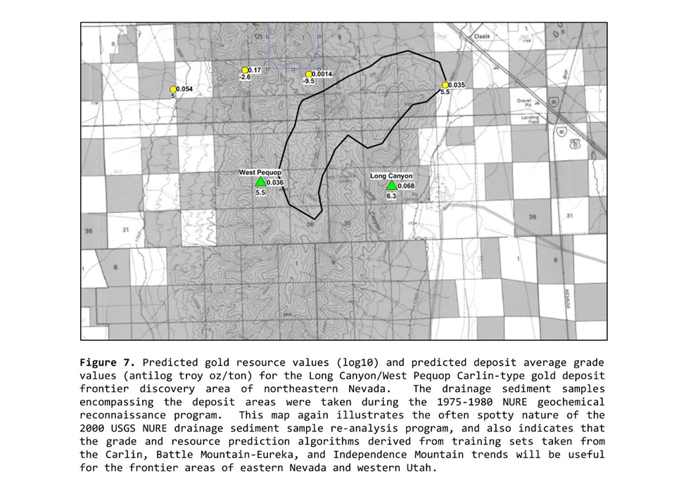
The Shape and Extent of Stream Sediment Geochemical Anomalies surrounding Well-Defined Carlin-Type Gold Deposits
The map boundaries of the surface drainage cells containing geochemical stream sediment anomalies identified using the novel geochemical method, and marking a sample of the Carlin gold deposits discovered after the 1975-1980 NURE drainage sediment sampling program, are provided below. Square mile section boundaries are shown on each topographic map. Darkened sections are public lands while undarkened areas are private lands. Approximate deposit location centers are marked with green-filled triangles. Stream sediment sample locations are denoted by small yellow-filled circles.
Surface sample predicted gold resource values (log10 troy ounces) are placed in the 6 o’clock position below each sample site marked with a yellow circle, while surface sample predicted average ore grade in ounces per ton is shown in the 3 o’clock position to the right of the yellow sample location marker. The published defined resource magnitude and published defined average ore grade for each Carlin-type gold deposit take the same 6 and 3 o’clock positions with regard to the green-filled triangle deposit location markers. The gold deposit gold resource values are those published as of the 2015 year of construction of these maps.
The Modest Springtime Proposal
DIR Exploration, Inc. (“DIR”), my employer, has two primary motives for seeing that this post was written, and for presenting the proposal that is described following the preliminary recitation of DIR’s two motives:
DIR’s field and office work on the Nevada Carlin-type gold deposits using its novel geochemical method identified almost 150 thus far unstaked and unmined stream sediment drainage cells, each containing apparent (regression-estimated) gold resources of 10^6.5 troy ounces or more. Unfortunately, DIR itself can itself no longer readily conduct follow-up Nevada fieldwork on these project-scale geochemical anomalies, but would still like to arrange that follow-up exploration fieldwork be conducted on each of these identified greenfield projects.
Given the field and laboratory data and other evidence already obtained in both Arizona and Nevada, DIR believes its novel geochemical method merits follow-up prospect-scale exploration testing. Should prospect-scale tests of the novel method be successful in discovering and defining ore resources reasonably close to the order of magnitude predicted within the drainage cell location(s) identified, eventual announcement of such discoveries would be extremely helpful in convincing and encouraging other geologists to master and adopt the novel geochemical method as a means of working around the shallow deposit exhaustion problem currently hindering the mineral exploration and mining industries. If the novel geochemical method is valid and reliable as available evidence already indicates, its more general adoption would also do much to restore much-needed profitability, and “supplier power” to the mineral exploration industry – and, most importantly, to mineral exploration geologists themselves.4
Following these two motives, I’d like to suggest that interested individual geologists willing and able to conduct independent greenfields gold exploration fieldwork in Nevada contact me through DIR’s business email address provided below to express interest should they possibly like to obtain exclusive knowledge of the locations of a small number (say, 1 to 3) of the approximately 150 anomalous drainage cells identified by DIR in northern Nevada. Each of these anomalous drainage cells is located on open, stakeable public lands and shows geochemically-based evidence of containing 10^6.5 troy ounces or more of Carlin-type gold resource.
In exchange for these drainage cell location disclosures, DIR would obtain and retain a small, consulting geologist-sized carried NSR royalty on the mineral resources contained within, and obtain a written agreement containing this and other assurances and protections customary to agreements establishing and protecting mineral and intellectual property rights.
Entirely crucial to satisfying DIR’s motive no. 2 above, “other assurances” would include a provision that the geologist receiving disclosure from DIR would publicly acknowledge, as soon as is possible, the role that DIR’s novel geochemical method played in the discovery (if any) of a previously unknown Carlin-type gold deposit located within a prospective greenfields project location identified and disclosed by DIR to the exploring geologist concerned.
DIR’s contact email for geologists interested in potentially pursuing this proposal is ldturnerdir [at] gmail.com. Please attach, if you will, your professional CV with your first email contact. Thanks.
The geochemical data-handling procedure used in the Arizona depth vs. geochemical signal graph was originally developed and used by geochemists of the former USSR. See the dropbox link report provided in the call out box above for the USSR reference.
Estimating average grade of the Arizona uranium deposits from surface sampling could not be attempted due to lack of published average ore grade data from the relatively few mined Arizona breccia pipe uranium ore deposits.
Note that pre-mining NURE stream sediment samples were re-analyzed under contract supervision of the USGS well after the termination of the 1975-1980 NURE program, using a standardized ICP-MS sample digestion and analysis procedure. These state of the art geochemical re-analyses were made public in 2000 and can be found at https://pubs.usgs.gov/of/2000/of00-421/.
The current impotency of the profession in more consistently and more frequently achieving new discoveries seems to have led many of the modern-day managerial rent-seeking “free riders” in the mining industry system to arrogantly and ignorantly adopt a chronic attitude of disrespect towards exploration geologists as a class. Hence, for example, the repeated stories of certain managerial ‘financial types’ boasting that they treat “their” geologists like mushrooms: “…by keeping them in the dark and eating horseshit.”